Travel
Passengers stuck on planes and homes without power in Storm Ashley disruption

 BBC
BBCAbout 1,500 homes and businesses in Northern Ireland remain without power as a result of damage caused by Storm Ashley on Sunday.
Northern Ireland Electricity (NIE) said it has restored power to more than 10,000 customers after outages.
Meanwhile, passengers were left on board airplanes at Belfast City Airport for a number of hours after landing due to Storm Ashley.
The airport was unable to bring steps to the aircraft due to the high winds and planes had to queue to pull up to a land bridge so people could disembark.
“We were able to fly over in a storm from Alicante to Belfast and landed safely but we can’t get off the plane,” Tracey Godfrey from Comber told BBC News NI.
On social media Belfast City Airport said the safety of passengers and staff was of the utmost importance.
“The crew have been brilliant in updating us, but we’re number four in a queue of five planes,” added Ms Godfrey.
Eamonn O’Sullivan, was also on the flight from Alicante to Belfast.
He described the landing as “very, very difficult” with a lot of turbulence.
After landing, passengers were kept on the runway for almost three hours.
Speaking to BBC News NI after he got odd the plane, Mr O’Sullivan said he was surprised that the plane took off in the first place.
“The winds were well forecast, it shouldn’t have taken off if you were going to left on the runway for nearly three hours,” he said.

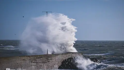 RBM Photography
The Met Office had issued an amber warning for western counties until 20:00 BST.
The weather station at Killowen, County Down, recorded a gust of 81mph (130km/h) on Sunday afternoon.
A yellow warning for wind remains in place for all of Northern Ireland until midnight as gusts of up to 70mph (115km/h) have been predicted.
Translink also warned of delays and disruption to rail travel.
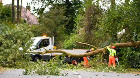 Pacemaker
Dozens of flights, mainly with Aer Lingus, had been cancelled at Belfast City Airport and Dublin Airport on Sunday.
Belfast City Airport asked passengers to check the status of their flight before travelling to the airport.
Allow Twitter content?
Meanwhile Stenaline and P&O sailings between Northern Ireland and Scotland are heavily affected, with most sailings on Sunday cancelled.
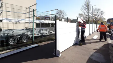
Northern Ireland’s Department for Infrastructure said temporary tidal flood defences were being deployed along the River Lagan at high-risk areas such as Lockview Road and Cutters Warf in south Belfast.
 pacemaker
Newry, Mourne and Down District Council said the district’s four forest parks (Castlewellan, Delamont, Kilbroney and Slieve Gullion) are closed to the public on Sunday due to the increased likelihood and risks associated with falling branches and debris.
Fermanagh and Omagh District Council have also announced closures of some outdoor council facilities, including Gortin Glens Forest Park.
And in the Derry City and Strabane District Council area, all public parks and grass pitches are closed as are recycling centres at Pennyburn, Strathfoyle, and Strahan’s Road.
Armagh City, Banbridge and Craigavon council announced that there may be a delay in opening household recycling centres on Monday.
Allow Twitter content?
Met Éireann, who issue warnings across the Republic of Ireland, named the storm and issued its second-highest level of warning – Status Orange – for counties including Galway and Mayo, from 10:00 local time on Sunday until 20:00.Very strong winds are forecast across the whole of Ireland and parts of Great Britain, especially Scotland.
Along exposed coasts and high ground, gusts may reach up to 70-80 mph (113-129km/h).
There are around 29,000 homes and businesses without power in the Republic of Ireland.
At one stage on Sunday that number was more than 50,000.
The Met Office have issued an amber warning for wind for counties Fermanagh, Tyrone, Londonderry and parts of Antrim from 13:00 until 20:00. It’s the second highest level of alert and the meteorological service says “some disruption to transport and power supplies is likely”.
The entire west coast of the Republic of Ireland is under an orange warning.
That’s the second highest level of warning and indicates an increased risk of damage and disruption.
Met Éireann is forecasting coastal flooding, difficult travel conditions, and dangerous seas along counties Clare, Kerry, Donegal, Galway, Leitrim, Mayo, and Sligo.
A yellow warning was issued across the rest of the country from midnight on Saturday until 03:00 BST on Monday.
‘Do not place yourself or others in unnecessary danger’
The Police Service of Northern Ireland (PSNI) are advising road users to consider if their journey is necessary and to take extra care if travelling.
In a statement they said: “If you must travel, please bear the prevailing conditions in mind. Your journey may take longer than normal, please drive slowly to minimise the impact of wind gusts, and be aware of high-sided vehicles on more exposed roads. Fallen trees or flying debris are possible in the gale force winds.”
Assistant Chief Constable Davy Beck added: “Consider the potential risks before you leave. Do not place yourself or others in unnecessary danger.”
Why are storms named?
The latest storm name season started on 1 September and will be used until 31 August 2025.
Ashley is the first name on the alphabetical list so the next storm would be named Bert, followed by Conall.
Storms can be named by the Met Office, Met Éireann or the Netherlands meteorological service (KNMI) if any believe impacts from severe weather are “medium” or “high”.
It is thought that by naming storms, it gives the public a greater awareness of the potential impacts of severe weather.

Inside the world’s only underwater roundabout between Scotland and Iceland

Front row rejects ‘other clubs’ as he has ‘unfinished business’ at Scottish outfit

‘World-class’ Schoeman signs long-term Edinburgh deal
‘World-class’ Schoeman signs long-term Edinburgh deal

Massive 874-Mile Snowstorm to Blanket the UK: Scotland and Northern England Brace for Heavy Snowfall Impacting Travel and Tourism – Travel And Tour World

Scotland’s railway achieves a fundraising milestone for Poppyscotland – Travel And Tour World

SNP and Labour clash over taxes as Scotland loses 10,000 retail jobs

Where to watch St Mirren vs. Rangers live stream, TV channel, start time, lineups, prediction for Scottish Premiership match | Sporting News

Scottish psychotherapist urges debate on youth social media use after Australia’s ban – Scottish Business News
